The weather forecast continues to improve, friends:
A 20 percent chance of showers before 10 a.m.
Cloudy, then gradually becoming mostly sunny, with a high near 54.
North northeast winds around 10 mph.
Light to no rain, and it ends as we begin. Mild winds. Cool enough to work up a good paddling sweat. Awesome!
Just a reminder to newcomers, we do not have boats available for rent or loan at the event. The best place locally to rent boats is Nyberg's Ace in Sioux Falls, the one located at 12th St. and Kiwanis Ave. rents canoes and kayaks.
The River of the Double Bend Campground in Trent, S.D., might rent to you as well. I would Google them and call ahead if you are boat-needy.
See you tomorrow. Arrive ahead of time to give us all a chance to get acquainted and to ferry some vehicles to the dam.
We'll have a short safety briefing at approximately 9:45 a.m. with hopes of launching shortly thereafter. In summary: Safety is the No. 1 thing about this event. All other concerns are secondary.
But this is a safe route. We all need to be aware of strainers and debris, and stay way to the left of the dam at the end.
E-mail me if you have questions! See you tomorrow.
jbies0341@hotmail.com

Friday, April 24, 2009
Thursday, April 23, 2009
Better bring rain gear
Last year, the weather was perfect for our Earth Day event. So far the forecast for Saturday is a mixed bag.
The National Weather Service report as a 9:30 a.m. Thursday says this for the Flandreau area:
Rain likely, mainly before 1pm. Cloudy, with a high near 47. Breezy, with a northeast wind between 15-20 mph, with gusts as high as 25 mph. Chance of precipitation is 60 percent.
So don't forget your poncho. Or rain hat. We will run the river rain or shine, lightning would be the only factor that would lead to cancellation.
There is some road construction between Flandreau and Egan but our main N-S route should be open Saturday. But if you are coming up state highways be aware of possible detours.
And bring a poncho.
Monday, April 20, 2009
It's all coming together - five days out
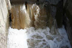
Weather reports say 60s, clouds, and perhaps some showers, but the river is living up to its end of the bargain for our April 25 cruise. This is the same overflow vent at the dam in Flandreau on April 18:
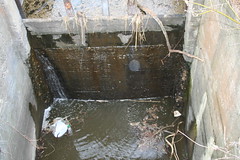
So the water levels are navigable, let's hope the rain holds off for our day on the Big Sioux River.
The put-in spot at the powwow grounds is in good shape, the water looks high enough that it'll pry be fine and dandy for the 10 a.m. launch at that spot. A reminder to anyone taking part, please remember we are hoping to get rollin' about 10 a.m. so come early to unload and get vehicles shuttled.
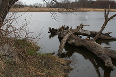
One issue in place is that the take-out spot at the Flandreau dam is currently blocked with this log.
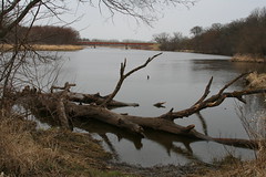
It does look like we can skirt it and still get out, it'd be nice if this log would just float down over the dam before Saturday, though.
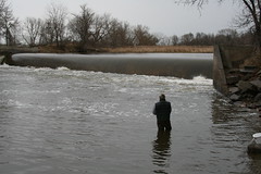
The down-river side of the dam is now out of the water. A fisherman said the water felt warm to him on Saturday last, and those taking off at noon to go to Egan should have plenty of space to park, launch, and get on down the river.
Here's a look at a spot on that downriver side:
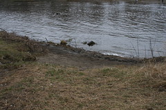
This photo shows the recession of the water. Just a few weeks ago it was so high, there was literally 20 feet between the two sides. Now it'll be a short 50-meter hike.
Save for that log, everything is looking rosy. Feel free to write me if you have questions about this event.
Remember to pack dry clothing. There should be plenty of people on this trip and we will all work together to keep people upright and safe. But if you tip, you'll be wet and cold and while it might not seem like fun to get out and change, you'll be thankful you have dry clothes with you.
Here's to hoping the rains hold off for a few hours - bring your rain gear though.
See you Saturday!
To recap:
Powwow grounds launch target time: 10 a.m.
Sierra Club Flandreau dam launch time: Noon.
Distance from powwow grounds to dam: About 9 miles (2-3 hours)
Distance from Flandreau to Egan: About 7.5 miles (2-2.5 hours)
So the water levels are navigable, let's hope the rain holds off for our day on the Big Sioux River.
The put-in spot at the powwow grounds is in good shape, the water looks high enough that it'll pry be fine and dandy for the 10 a.m. launch at that spot. A reminder to anyone taking part, please remember we are hoping to get rollin' about 10 a.m. so come early to unload and get vehicles shuttled.
One issue in place is that the take-out spot at the Flandreau dam is currently blocked with this log.
It does look like we can skirt it and still get out, it'd be nice if this log would just float down over the dam before Saturday, though.
The down-river side of the dam is now out of the water. A fisherman said the water felt warm to him on Saturday last, and those taking off at noon to go to Egan should have plenty of space to park, launch, and get on down the river.
Here's a look at a spot on that downriver side:
This photo shows the recession of the water. Just a few weeks ago it was so high, there was literally 20 feet between the two sides. Now it'll be a short 50-meter hike.
Save for that log, everything is looking rosy. Feel free to write me if you have questions about this event.
Remember to pack dry clothing. There should be plenty of people on this trip and we will all work together to keep people upright and safe. But if you tip, you'll be wet and cold and while it might not seem like fun to get out and change, you'll be thankful you have dry clothes with you.
Here's to hoping the rains hold off for a few hours - bring your rain gear though.
See you Saturday!
To recap:
Powwow grounds launch target time: 10 a.m.
Sierra Club Flandreau dam launch time: Noon.
Distance from powwow grounds to dam: About 9 miles (2-3 hours)
Distance from Flandreau to Egan: About 7.5 miles (2-2.5 hours)
Tuesday, April 14, 2009
Tantalus
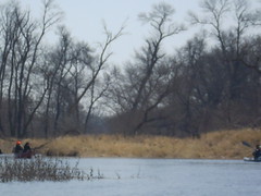
Talented South Dakota photographer Greg Latza was out paddling Lake Lakota near Newton Hills last weekend. If these great photos do not tantalize you, nothing will.
Thanks for sharing your photos with the SDCA, Greg.
http://www.greglatza.com/kayak/index.html
Thanks for sharing your photos with the SDCA, Greg.
http://www.greglatza.com/kayak/index.html
One week from Saturday
 The April 25 cruise/Earth Day event is coming up quickly, and the river levels are more modest, so we should have a dandy event.
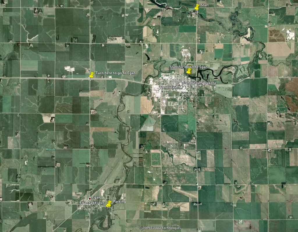
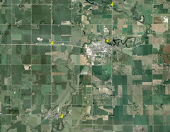
 Included in this post are several map photos; if you click on one, you'll go to the page where the image is stored. There, click on the "all sizes" choice and you'll get a larger view of the image and the place marks I have added.
This first one is an overview map of the entire route, from the powwow grounds north of Flandreau to Egan.
Remember, this trip is layered. Paddlers can start north of Flandreau and paddle to the dam and be done. Or start at the dam and paddle to Egan. Or do the whole thing.
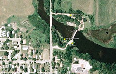
Here's a close-up of the put-in spot at the powwow grounds:
We want to remind everyone to pack sunscreen and water. There's a rush that comes with getting back out after a long winter, but don't let that rush overcome your logic: Spring sun will burn you just as much as June, July, and August sun.
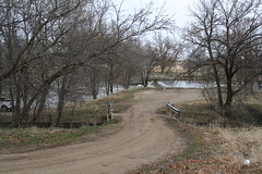
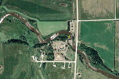
Here's a look at the dam - there's plenty of parking on the nearside, and if we run out there's a ton on the other side of the river.
Another important reminder: Bring a dry bag with a spare set of clothing. The water will be bone-chilling and a simple mistake can lead to dangerous conditions. Having dry clothes along might seem superfluous but it could save a life. Both the Moody County Sheriff's Dept. and the Flandreau Police Dept. know of our endeavor, but a dry set of clothes along with could save you a trip to the hospital. Be safe.
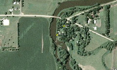
Here is a look at the Egan take-out spot, there's tons of parking there.
The nice thing about this route is the ease of shuttling vehicles. It's literally a 5-minute drive from the powwow grounds to the dam, and only about 4 miles from the dam to Egan. This map shows the overview, including a marker where one would turn to go down to Egan just west of Flandreau.
I hope these maps help. Feel free to e-mail me if you have questions about the route, what to pack, etc. It's going to be a great cruise!
Monday, April 13, 2009
Seeking input on Sioux Falls Big Sioux River
Our club president is going to meet with staff from Sioux Falls Parks and Recreation to discuss ideas on improving access and use of the Big Sioux River in the Sioux Falls area, especially on the green way where the bike paths are located.
Gene Preston seeks input from all paddlers familiar with the river in the Sioux Falls area before Wednesday, April 15.
The more paddler input/insight we can give them, the more likely future construction/development will take into consideration all users, including canoe and kayakers.
Share your knowledge of the river - and places where changes might be needed - with Gene by either posting a comment to this blog entry, or by e-mailing Gene at tamarackprest@alliancecom.net. You will probably have to cut and paste the e-mail address above into a new message to him to make it work.
Or feel free to e-mail Jarett and he will relay the information to Gene.
On another note, the Big Sioux has gone down nicely in the Flandreau area for our April 25 endeavors. We should be in great shape for a nice outing on the river. Crossing fingers for low winds and high temps.
Saturday, April 4, 2009
SDCA members gather information on Big Sioux banks, water quality
Two of our club members, Dave and Mary Finck, took part in the East Dakota Water Development District’s April 1 discussion about the Big Sioux River. A speaker from the Department of Environment and Natural Resources, along with engineers, presented information on the eroding banks and plans to slow this problem.
Sol Brich of the DENR said a project is underway to add riprap to the toes of certain high banks. Other steep banks will be cut to more gentle slopes, and an effort is underway to get native grasses with deep roots planted on the slopes to fight future erosion. Farmers who own land along the BSR will receive payment for planting these grasses.
Here's a salute to both the East Dakota Water Development District and the DENR for having the meeting. As a club, we value the BSR greatly; we hoping we can support the efforts and spread the word.
Our thanks go out to Dave and Mary for bringing back this information for all of us.
Mary Finck said the discussion included fecal matter contamination in the river.
The native grasses program also includes a component that would help farmers maintain fences to keep livestock away from the river’s edges. With these fences, the grass can grow and reinforce the banks, and less manure close to the river will wash into the water after rains.
The DENR needs help: Photos of banks, feedback from paddlers and landowners, volunteers to support the evaluation of sites, and more volunteers to continue water-monitoring efforts. If you want more information, or would like to find out how to help, call Jay Gilbertson or Roger Strom, both with the East Dakota Water Development District, at (605) 688-6741.
Subscribe to:
Posts (Atom)